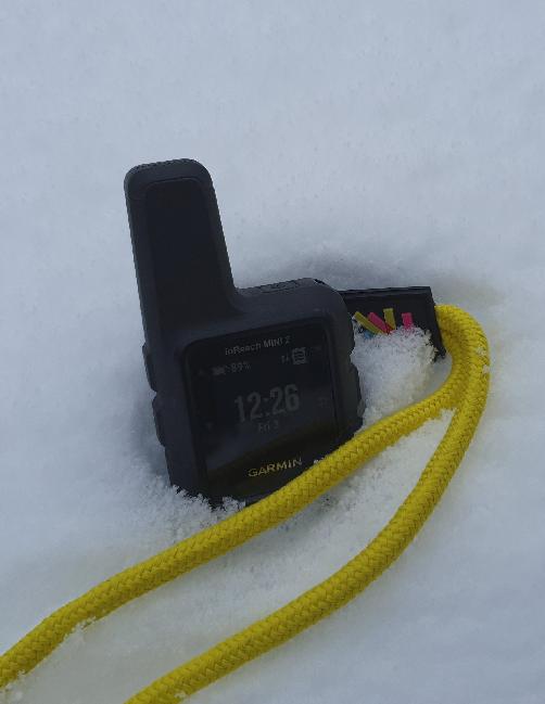
The Garmin InReach Mini 2 keeps fascinating me beyond the 9 blog entries I made last year, so needless to say, I took it with me to a recent vacation in the Austrian alps. While experimenting, I had two interesting insights that I thought I should document here: Message time context and where around the globe SOS emergency messages are being sent.
One thing I kept asking myself was if the time shown next to an incoming text message is actually the time the message was received or if it was the time it was sent. On mobile phones that use a cellular or Wifi network, these are usually the same. Over satellite, however, there can be a significant delay delivering the message for two reasons:
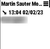
The device does not see a satellite for quite some time or the message arrives outside the 10 minutes receive window after a messages was sent in the first place. To save power and reduce signaling load of the system, the device only checks once an hour for new messages after that 10 minute time window has expired. And while in many cases it might not matter just when a message was sent, there are quite some scenarios when its important to know if the message that was just received was sent just a few seconds, a few minutes or a few hours ago. It turned out that the time and date shown above a received message is the time the message was originally sent. The time the message was received can be queried in the ‘details’ part of the message as shown in the second screenshot.

When sending a satellite message to an SMS recipient, however, no ‘sent time’ is delivered to the other side. That’s a bit of a pity, as the recipient thus can’t know if the message that was just received sat in the outbox of the Mini 2 for a longer time until a satellite could finally be acquired. Again, context matters in some cases.
While my main application for my InReach devices is to be able to send and receive text messages should terrestrial networks fail at my location, I also wondered where people would use the device to send SOS emergency messages to Garmin. A few weeks ago, Garmin posted some details of this in the light of the 10.000th SOS incident received. The map in this post is quite interesting!
From a European point of view, it’s probably not surprising that most SOS incidents in the southern part of Europe occur in the Alps. While mobile network coverage is excellent in the mountains around skiing resorts, networks fade away pretty quickly in remote places less frequented by tourists as I noticed very quickly on a sled tour through a nature reserve.
Spain and the UK also have quite a number of dots and in the case of the UK, I’m quite a bit surprised, as, apart from the Scottish highlands, I always perceived the country to be densely populated. Norway is also plastered with dots, but strangely enough, there were not many incidents in Sweden and Finland. Perhaps the Norwegian fjords are more interesting from a backpackers point of view compared to the Swedish or Finish outback? Anyway, interesting data!