How much of the sky can be obstructed for Starlink to still work without connectivity breaks (in Germany)? This has been one of the most important questions I had about Starlink before I could try it out on my own.
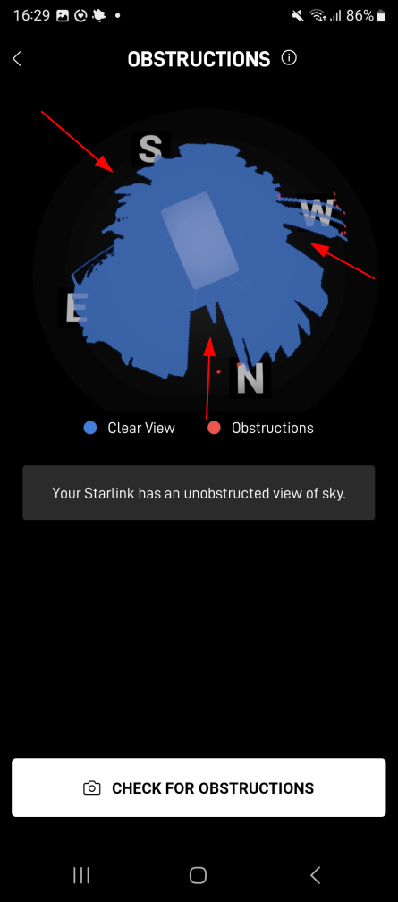
Here’s an image that shows an obstruction diagram, which the Starlink app on a smartphone produces after ‘Dishy’ has been up and running for about 6 hours. The blue sphere shows the parts of the sky that are visible, while the black area shows where obstacles are in the way. The red arrows were put into the image by me. For this image, the Starlink dish was at my rooftop, and the sky was blocked as follows:
1) About half the sky to the south was completely blocked by a near vertical part of roof, which is about 2.5m high (red arrow on the top left). Dishy was about 0.5m away and hence, this part of the roof pretty much obstructed half of the sky.
2) Towards the north, there was a solid obstacle about 1 meter away and about 1.5 meter high which is also shown nicely on the image (red arrow at the bottom.
3) And finally, there was another 1.5m high obstacle towards the west, also around 1m away from the antenna, which also blocked the sky.
I would say it’s a fair representation of the environment. The installation has no camera, so the image must have been derived based on the knowledge where the satellites were supposed to be over the course of time and when they came into view.
So in total, more than half the sky was blocked for Dishy. Still, I didn’t have any interruptions of my Internet connection over the days I had Dishy installed at this location.
Next up: A closer look at the 5 GHz Wifi of the Starlink router.