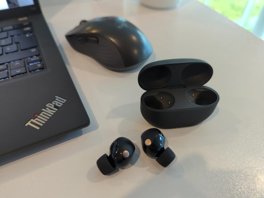
NTN – Part 4 – Satellite and Mobile Operator Mix and Match

This part is the seamless continuation of part 3 on the 3GPP TS 36.300 and TS 38.300 extension for Non-Terrestrial Networks, i.e. satellite communication. So let’s jump back straight in. Before we talk more about specific architecture options, here are two more terms used in the specification that are important to understand:

As discussed in the previous posts, the satellite acts as a ‘bent-pipe’ repeater in the 3GPP specifications for satellite communication, and the eNodeB / gNodeB base station is on the ground. This means that instead of a direct link between a mobile device and the base station, there are now two legs in the connection: First, there’s the radio link between the mobile device and the satellite, which is referred to in the specifications as the ‘service link‘. And then, there’s the link between the satellite and the base station on the ground, which is referred to as the ‘feeder link‘. As the satellite is ‘only’ a repeater from an overall system point of view, both links carry the same radio signal. However, it is possible that the service link and feeder link use different frequency bands, i.e. the repeater in space (the NTN payload, see previous post) must be able to change the carrier wave frequency of the signal.

That being said, lets have a look at the different NTN network architecture options specified by 3GPP:

Continue reading NTN – Part 4 – Satellite and Mobile Operator Mix and Match

Reality Bites – Flight Simulation – Part 7 – SimBrief and Navigraph

When flying with Visual Flight Rules (VFR) in the simulator, I’ve come to rely on SkyDemon, a real world tool to plan VFR flights and then use it during the virtual flight to find my way and to avoid ‘Charlie’ airspace and restricted areas. When flying with Instrument Flight Rules (IFR), other real life tools such as ForeFlight are an interesting option to use in the simulator. However, ‘the Internet’ seems to conclude that the combination of SimBrief and Navigraph for flight planning and flying is a better alternative for the simulator. I was a bit skeptical at first, because I want my simulator flying as close as possible to the real world, but I gave it a try anyway. So here’s how that went:

Continue reading Reality Bites – Flight Simulation – Part 7 – SimBrief and Navigraph

NTN – Part 3 – 3GPP Rel. 17 – System Architecture for Satellite Services

In part 1 of this series, I’ve taken a high level look at how the LTE and 5G air interface specifications have been extended in 3GPP Release 17 to accommodate for weaker signals, longer delays and patchy coverage typically experienced over satellite. In part 2, I’ve chased the question why the LTE NB-IoT and CAT-M in particular have been extended and which features they have that are also very useful if a smartphone or other mobile device communicates via a satellite. In this part, I’ll now have a closer look how the overall 3GPP LTE and 5G System Architecture has been enhanced in 3GPP Release 17 for use with Non-Terrestrial Networks (NTN).

Continue reading NTN – Part 3 – 3GPP Rel. 17 – System Architecture for Satellite Services

When All Else Fails – The Garmin InReach Mini 2 – Part 12 – Capacity for InReach

Wow, this is already part 12 in my blog series on the Garmin InReach Mini 2 and the underlying Iridium satellite constellation. Perhaps you remember, my main use case for the Mini 2 is to have a means to communicate with family members in other countries should there be a longer network outage, be it local or more widespread. While the service works great during normal times, I wonder of course if and how quickly Iridium would get overloaded, should there be a widespread terrestrial network outage. So I made a number of assumptions to chase the answer, or to get at least a basic feeling for this.

Continue reading When All Else Fails – The Garmin InReach Mini 2 – Part 12 – Capacity for InReach

NTN Part 2 – NB-IoT over Satellite

In the previous post on the topic, I’ve been looking at how 3GPP has studied and then extended the LTE and 5G NR air interface so it can be used over a satellite link. For transmitting data to and from smartphones with omnidirectional antennas over satellites, 3GPP has extended the LTE Narrowband Internet of Things (NB-IoT) air interface. But why a narrowband technology for Internet of Things applications, all the hype is around satellite connectivity for smartphones these days!? Thanks to the experience gained with my Garmin InReach Mini 2, I think I have a pretty good idea why. So let’s have a look at the limitations of a satellite link to small mobile devices and which nifty features that are part of terrestrial NB-IoT can also be very useful for this type of satellite communication.

Continue reading NTN Part 2 – NB-IoT over Satellite

Creating My Own Filter Bubble In Mastodon

Before the recent Twitter implosion, Mastodon was a nice place. I typically followed others that had interesting things to share, which means, to me, ideas and projects that would better me professionally or personally. It was a joy to browse through my timeline in the morning and there was hardly a day when I didn’t pick up an interesting idea. But then Twitter imploded and Mastodon saw a massive influx of new people. This totally changed the equation for me.

Continue reading Creating My Own Filter Bubble In Mastodon

Reality Bites, Part 6: The G3000 Avionics on Steroids in That Simulator

Approach to virtual Frankfurt airport (EDDF) in twilight conditions. Right click to enlarge.

In the previous post back in January on my flight simulator adventures, I’ve described my step from a small propeller plane to the somewhat more powerful turbocharged Daher TBM 930. While that doesn’t give a lot of benefits from a Visual Flight Rules (VFR) perspective, having a faster plane for Instrument Flight Rules (IFR) flying is a great thing, as it offers additional range and hence, more controlled airports to fly into. This is particularly helpful when flying in the Vatsim environment, where ‘real virtual’ air traffic controllers keep you save in the sky, but only cover select larger airports. The catch so far: The Garmin G3000 flight management system (FMS) has lacked a number of important features so far, which made IFR flying quite a bit more challenging, particularly in high workload situations. So I was really delighted that in the update in January 2003, the G3000 avionics got a major overhaul. Let’s have a look at that.

Continue reading Reality Bites, Part 6: The G3000 Avionics on Steroids in That Simulator

Price Development of My Used Z440 Workstation

Image: Cooling on top of a Xeon E5-1650 v4 processor

About two years ago, I bought a 5 year old used HP Z440 workstation with a 6 core Xeon E5-1650 v4, 32 GB of RAM and an Nvidia M2000 graphics card for around 800 euros. At the time I wanted to have some CPU processing power with little noise and an Nvidia graphics card that could do H.264 video encoding and decoding in hardware. This turned out to be a great investment, as I use the workstation daily to run a number of computing intensive virtual machines and also make good use of the hardware video encoder, all with pretty much zero noise emission from below the desk. By now, the hardware is about 7 years old and one would think that even refurbishers would be out of stock by now and sell the system at a significantly lower price. Turns out that this is not the case.

Continue reading Price Development of My Used Z440 Workstation

5G n78 Shines in the Austrian Alps

Recently, I’ve been on a two week skiing trip in Bad Gastein, a small village in the Austrian alps. As usual and also because my default cellular connectivity did not meet my needs, I had a closer look at the local connectivity options and gained some interesting insights.

For testing purposes and of course for redundancy, I have subscriptions of two premium mobile network operators in Germany, and both usually also provide excellent service while roaming. During the day, LTE data rates in the automatically selected roaming network were well beyond 100 Mbps in the downlink and well over 80 Mbps in the uplink. 5G was not yet available on the local cell tower, but at those data rates, I didn’t really mind. In the evenings, however, the automatically selected network got more and more loaded, and by 8 pm, downlink speeds consistently slowed to 1-2 Mbps. Also, round trip times increased from 100 ms to well over 200 ms. In the uplink direction, however, I still got 50 Mbps. A clear sign of congestion and totally unusable for many things.

Continue reading 5G n78 Shines in the Austrian Alps

When All Else Fails – The Garmin InReach Mini 2 – Part 11 – More About Power Consumption

In part 6, I’ve taken a look at how much power my Garmin InReach draws in various scenarios. Depending on where the device was located and used throughout the days, the battery would last me anywhere between 16 days in the best case and only a single day in case no satellite can be reached all day long. On a recent skiing trip , I now had a look how long the battery would last it tracking, i.e. location recording was enabled in addition to sending and receiving the occasional message over the Iridium network.

Continue reading When All Else Fails – The Garmin InReach Mini 2 – Part 11 – More About Power Consumption